Enregistrez gratuitement cette image
en 800 pixels pour usage maquette
(click droit, Enregistrer l'image sous...)
|
|
Réf : T01417
Thème :
Terre vue de l'espace - Iles - Récifs (286 images)
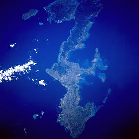
Titre : Okinawa, Ryukyu Islands August 1991
Description : (La description de cette image n'existe qu'en anglais)
Okinawa, the largest of the Ryukyu Islands Archipelago, is visible in this near-vertical photograph. The long, narrow, irregular-shaped island of Okinawa, which is volcanic in origin, covers 454 square miles (1176 square kilometers). The southern half of the island is surrounded by coral formations; the northern half is mountainous, rising to 1657 feet (505 meters) above sea level, and is covered with dense vegetation (darker green). Most of the population and the agricultural areas, which produce sugarcane, sweet potatoes, and rice, exist in the southern half of the island. Fishing is also an important industry. The large U.S. military airfield at Kadena is discernible near the center of the photograph. Okinawa was the site of one of the bloodiest campaigns of World War II (March through June 1945). Under United States control since August 1945, the island was returned to Japanese control in May 1972. Negotiations in April 1996 called for some U.S. military installations to be closed and the land returned to the people of Okinawa; however, numerous U.S. military installations remain scattered throughout the island.
|
|

